

Now Reading: Best Places Visiting in Bokaro – Explore Top Attractions & Hidden Gems
-
01
Best Places Visiting in Bokaro – Explore Top Attractions & Hidden Gems

Best Places Visiting in Bokaro – Explore Top Attractions & Hidden Gems
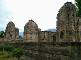
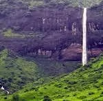
1.Satanpur Hills

The Chas block of Bokaro district serves as the home of Satanpur hill. Semaphore Tower exists on the mountain summit where the British East India Company built it approximately 200 years ago.
Semaphore towers operated as distance-reaching communication devices. The British East India Company operated this system as a bulletproof telecommunication network. Sending information through semaphores depends on visible objects which become a medium for transmitting data. A height is selected to mount the visual object (this occurs on top of a tower). The information was accessible through the status of the physical objects.
This double-story semaphore tower on Satanpur hill holds great historical significance to the area. The tower represents British architectural heritage as it shows the design style characteristic of that time period. The series of towers extended directly from Fort William in Kolkata toward Chunar with all towers placed in sequence. Chunar lies approximately 694 kilometers away from Kolkata at present. The research shows that forty-five semaphor towers exist along a linear path at distances spanning from 9.5 to 13 miles in between each tower. The tower system allowed direct communication between Fort William in Kolkata and Chunar during clear days in a period of fifty minutes.
British builders constructed two-story semaphore towers at hilltops but they created four-story high minarets in plain areas. Every tower contained viewing windows which appeared on both exterior sides. These semaphores had attached binoculars for observation. Through the telescope he captured the signal from the neighboring tower which he then forwarded to the following tower. These towers were built around 1813.
The right time to arrive
Despite its cool climate Satanpur provides its most ideal conditions for exploration from October to March. The period between October and March provides favorable conditions for tourists who wish to appreciate the scenic views across the dam’s construction.
Places to visit: Satanpur Hills
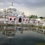
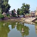
2.Banaso Temple

History of the temple: –
One person was following the traditional method of field harvesting by cutting the ram while a stone accidentally struck his spade. Milk flowing with cotton came out of the stone when the spade struck it. People built the temple at that location after they recognized the small stone as a goddess incarnation.
Banaso Ma Banaso resides as a vine tree on this location. According to local belief the residence of his mother remains in the same household. Any person who comes to seek blessings at this location emerges with what they desire.
The divine temple situated along the Konar river maintains its exquisite character through natural beauty. Aside from hills that border the railway track lies the flowing Konar River on the opposite side. Other state residents marvel at the temple’s native splendor when they visit. The remarkable banyan tree stands as one of its kind.
The right time to arrive
- The ideal period to visit Banaso temple occurs during Navratri since Navratri ceremonies are celebrated at the temple. Endless trade in blessings with Maa Banaso remains open to devotees for constant representation.
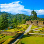
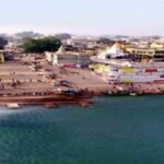
3.Konar Dam

The major reservoir of Konar Dam exists within Bokaro district of Jharkhand state India. The Konar river serves as the foundation for the construction of the dam that received its establishment during the 1980s. Konar dam exists to provide water supply together with irrigation and flood control services and power generation capabilities. The water supply functions of this dam connect Jharkhand to Bihar. The length of the Konar Dam extends to 4,535 m (14,879 ft) while its maximum height reaches to 48.77 m (160.0 ft). The reservoir area expands to 27.92 km when it reaches its maximum capacity.
Important facts about Konar Dam:
- The facility stands on the Konar river in Jamadoba village which drains through Kau.
- Objectives: Mainly irrigation, reservoir and power generation.
- Through the hydropower station people generate electricity using this dam.
- The capacity of the dam for water storage is crucial because it helps minimize droughts and floods that threaten the neighboring areas.
- The area gains advantages for farmers because irrigation provides facilities to support their agricultural operations.
- Water sports and boating
- People can engage in boating along the massive reservoir area of the dam.
- Water sports in calm waters attract adventure-loving people who want to relax during their activities.
The right time to arrive
The proper period to visit Konar Dam extends from October to March. During this favorable months the pleasant cool weather sets the perfect environment for walking and picnicking activities.
4.Gawai Barrage

Gavai Barrage acts as a major water resource project situated in the Bokaro district of Jharkhand. The water resource development project stands built across the Gavai River that stems from the Damodar River. The project primarily exists to fulfill four requirements which result in water conservation and irrigation and provide drinking water and reduce flood risks.
The Gavai Barrage project obtained its primacy from its main target to supply irrigation to farmers across the area and improve regional water management. Government authorities in Jharkhand supervised the project completion through their Water Resources Department.
Best Time to Visit
Visiting Gavai Barrage yields its best experience during the period of October to March. The pleasant climate during this time invites visitors for picnics and tourism activities at the location.
Gavai Barrage operates as a site that demonstrates environmentally friendly water resource management which supports agricultural requirements together with industrial requirements and residential requirements and provides scenic vistas for visitors.
5.Ram Lakhan Tungri

Religious and historical importance defines Ram Lakhan Tungri because Lord Ram along with Mother Sita spent some time at the location while staying in exile for 14 years during Treta Yuga. This sacred site exists in Kasmar inside Bokaro which belongs to Jharkhand and is famous because Lord Ram passed through this territory.
Lord Ram visited the forests of Jharkhand during his time in exile even though one destination specifically stands out as Kasmar. Local traditions explain that the small hill where Ram placed his footprints became known as Ram Lakhan Tungri or Pakaha Dahake. When Mother Sita requested to have the golden deer Lord Ram entered the forest in order to fulfill her wish. The legend states that a mountain served as a killing point for a deer using an arrow during the Ramayana period making this location historically important.
Throughout Ram Navami people show deep devotion to Lord Ram at the Ram Lakhan Tungri location. The special tradition of Mahaviri flag hoisting during this celebration allows devotees to compete for placing the tallest and grandest flag. At this temple devotees can only present Lord Ram with candies as the sacred offering called prasad while the distributed prasad consists solely of candy.
related articles : Best Places Visiting in Udhampur – Explore Top Attractions & Hidden Gems


Pingback: Best Places Visiting in Chatra | Top Attractions & Hidden Gems